Posts

EGU 2018 and visiting Z_GIS

Image
From 8th to 13th of April I attended European Geosciences Union General Assembly in Vienna, Austria. The EGU General Assembly 2018 is massive conference with almost 5000 oral, 11 000 poster, and 1500 PICO presentations. There were 15 000 scientists. I attended mainly hydology and data management and modelling sessions which had very interesting and cutting edge presentations. I presented "Challenges in identifying small-scale wetlands using remote sensing" in session "Water Level, Storage, Floods and Discharge from Remote Sensing and Assimilation in Hydrodynamic Models".  I also took a chance to participate in different workshops from "How to communicate science" to "Google Earth Engine" and statistics. Attending Google Earth Engine workshop EGU venue After EGU we made a short visit to Geoinformatics Department in University of Salzburg where we also had an opportunity to visit  some field sites with sensor stations. Visiting fie

Publications

March and April were successful months in publishing outcomes of the project. Three papers on watershed management and nutrient modelling were published: Uuemaa, E .; Palliser, C.; Hughes, A. Tanner, C.(2018). Effectiveness of a Natural Headwater Wetland for Reducing Agricultural Nitrogen Loads. Water, 10 (3), 1−17.w10030287 . Pärn, J.; Henine, H.; Kasak, K.; Kauer, K.; Sohar, K.; Tournebize, J.;  Uuemaa, E .; Välik, K.; Mander, Ãœ.; (2018). Nitrogen and phosphorus discharge from small agricultural catchments predicted from land use and hydroclimate. Land Use Policy, 75, 260−268.10.1016/j.landusepol.2018.03.048. Uuemaa, E. ; Hughes, O. A.; Tanner, C. C.; (2018). Identifying Feasible Locations for Wetland Creation or Restoration in Catchments by Suitability Modelling Using Light Detection and Ranging (LiDAR) Digital Elevation Model (DEM). Water, 10 (4), 1−15.w10040464. In addition, one paper on hydrogeological data management: Kmoch, A.;  Uuemaa, E. ; Klug, H.; Cameron, S.

GIS day

Image
GIS Day is playing a powerful role in creating geographic awareness everywhere in the world.  More than 80 countries are participating in holding local events such as corporate open houses, hands-on workshops, community expos, school assemblies, and more. Since 1999 GIS Day has been celebrated in Estonia. There are many interesting events organized on the day: conference, teachers computer lab with GIS courses, exhibition of companies and GIS related institutions, map contest, sightseeings to exhibitions by National Library of Estonia etc. This year I made presentation on the conference on topic "Mapping and modelling wetlands with GIS"   GIS Day is a good opportunity to show the usability and usefulness of GIS science to the public and especially to high school students and teachers. Presenting at GIS Day in National Library. Photo by Aivo Vard

Presentation at the Annual Conference of Estonian Society of Geoinformatics

Image
On 29th of September I presented at  the Annual Conference of Estonian Society of Geoinformatics, Voore, Estonia. Estonian Geoinformatics Society (ESTGIS)  is an union that represents professionals in geographic information, cartography and other related disciplines in Estonia and it aims to  rise the geoinformatics awareness in societyand to contribute to the GI/GIS and related fields related development processes. The annual conference is a great opportunity to communicate your scientific results to the experts in the field who are not only working in academia but also in companies and governmental agencies. I was presenting my results on spatial analysis and modelling of wetlands in New Zealand. Presenting at Annual ESTGIS Conference, Estonia. Photo by Villem Voormansik

IWA DIPCON 2017: Effectiveness of a natural headwater wetland for removing agricultural nitrogen loads

Image
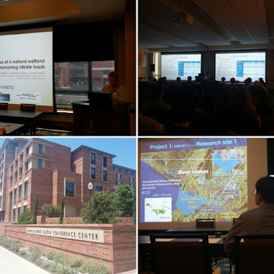
On 13th to 17th of August 2017 I attended IWA DIPCON (Diffuse Pollution and Eutrophication Conference) in UCLA, Los Angels, USA. The DIPCON addresses the latest and innovative approaches to fundamental and applied research. There were variety of interesting sessions on specific topics like stormwater management, monitoring and modelling, pollution control and best management practices (BMPs), sustainable urban drainage systems, reuse and resource efficiency, climate change adaptation related to diffuse pollution and eutrophication. I made an oral presentation on:  „Effectiveness of a natural headwater wetland for removing agricultural nitrogen loads“ Conference sessions and conference venue UCLA

Last days in New Zealand

Image
Last weeks in New Zealand were very busy with wrapping everything up. I'm grateful that I could work with such great people and learn a lot. Thank you all! I'll continue working on research started there and implementing the knowledge aquired at NIWA. With my two favourite Chrises from NIWA :)

Looking for wetlands on Routeburn Track

Image
Towards the  end of my stay in New Zealand I took the opportunity to walk one of the Great Walks, the Routeburn Track, which is location in the Mount Aspiring and Fiordland National Parks, south-west of the South Island. For the whole track over the distance of 32 km which I walked in three days. The track winds through beautiful beech forest, across tussock-covered flats, over the Harris Saddle, passes subalpine shrublands, alpine tarns and bogs. Most interestingly, even here science follows on the footsteps. I met a couple from Thames, Coromandel. They were dairy farmers and these few days on the track were their only only holidays for the last year. We had a great conversation about sustainable agriculture and manure management. They had apparently even won an industry award for best effluent management and  they collaborated with scientists and an innovative company that developed a solution to reduce the smell of a manure. That was a great example of scientists, entrepreneur